
Early results from a randomized trial indicate that where Bangladesh’s Department of Environment officials had ARCED’s tracker, enforcement moved toward the areas where kilns are estimated to do the most harm.
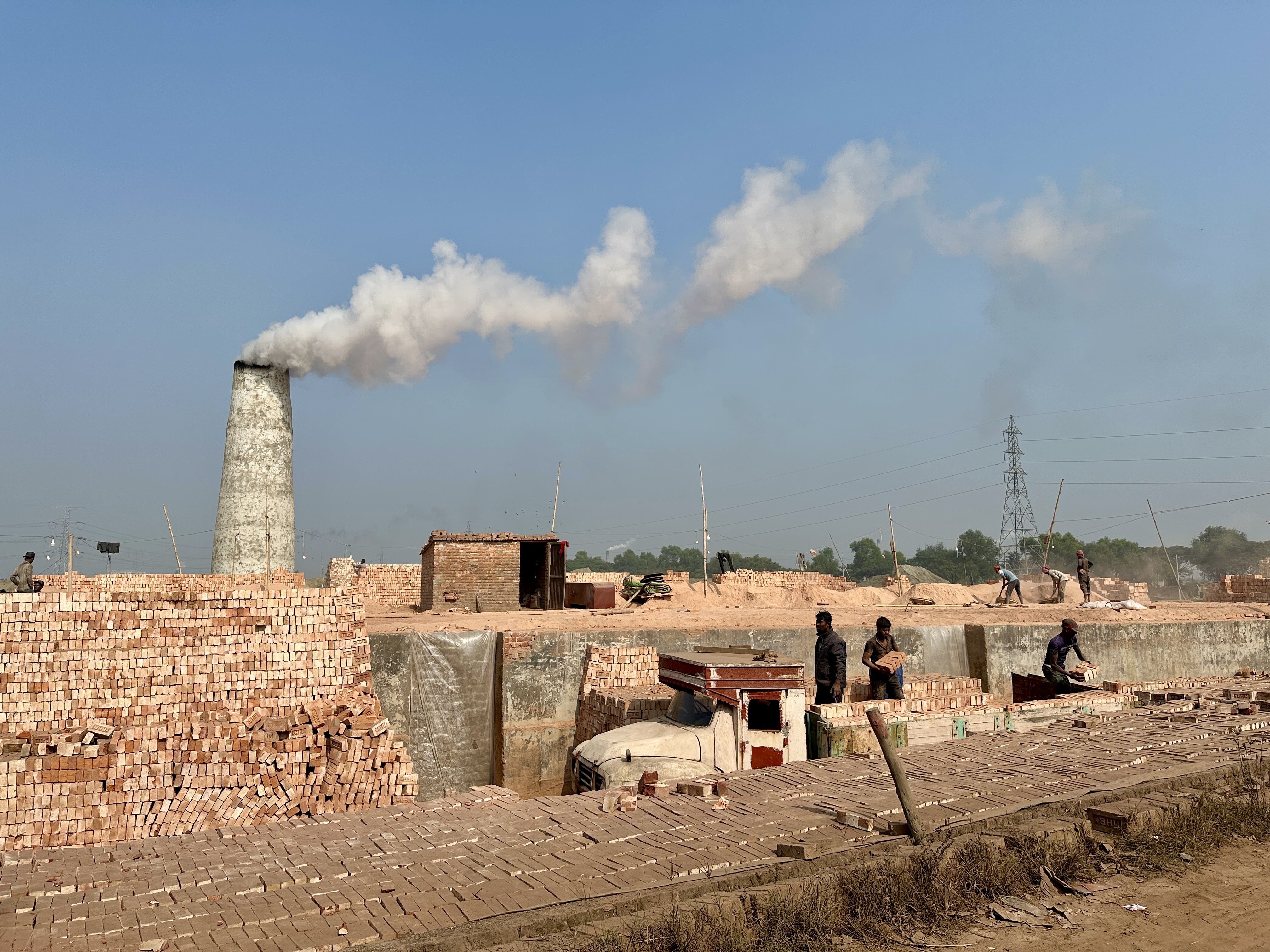
Every November, once the monsoon rains have passed, Bangladesh’s brick kilns begin firing for the season. Around each one, fields of freshly molded clay bricks dry in the sun before they go into the kiln, whose chimney sends smoke up into the sky. Both are visible from space. In mid-2023, satellite images showed 7,016 active brick kilns across the country.
The smoke from these kilns carries fine particles, known as PM2.5, that raise the risk of heart disease, stroke, chronic lung disease, lung cancer and lung infections. Bangladesh had the most polluted air of any country in 2023, with a yearly average more than 12 times the World Health Organization’s recommended maximum level. PM2.5 from all sources shortens average life expectancy by about 5.5 years compared with air that meets the World Health Organization’s guideline. That loss is nearly three times the global average. Brick kilns are a substantial part of this problem, with studies estimating that they are responsible for anywhere from 12% to 58% of air pollution. Researchers at the ARCED Foundation, a Dhaka-based nonprofit, and a team of international researchers led by Professor Martin Mattsson, an economist at the National University of Singapore (NUS), estimate that only 9% of brick kilns across the country - about 630 of them - account for a quarter of the health harms. Those few hundred kilns are where enforcement can do the most for people’s health. ARCED has built a dashboard to track the kilns with the greatest health harm.
Regulating the kilns falls to the country’s Department of Environment (DoE), whose officials decide which kilns to fine, which to order to switch to cleaner technology and which to close. ARCED’s tracker is meant to help them focus constrained enforcement resources on the kilns that harm the greatest number of people. The DoE has received no new money or staff to use the tracker, so the aim is to see whether the same enforcement has the potential to prevent more illness and death. With support from a DIV Fund Stage 1 grant, ARCED is testing in a randomized trial whether this approach results in the most harmful kilns closing, and whether this approach can work at scale.
So far, DoE officials have used the tracker, and early results indicate that where they had it, enforcement moved toward the areas where kilns are estimated to do the most harm, and kilns there were less likely to keep firing, compared to subdistricts without the tracker.
What we funded
The pilot is an RCT. DoE officials in 41 of Bangladesh’s 64 districts, chosen at random, have had access to ARCED’s tracker, and the other 21 districts serve as the comparison group.
Working closely with the DoE, ARCED first piloted the tracker in two districts: Dhaka and Gazipur in February 2023. Of the 10 subdistricts in these two districts, five were randomly selected. Dhaka and Gazipur were selected by the DoE based on their closeness to the capital and importance for the DoE’s Air Quality Management team. In a show of early interest and a nod to the partnership, DoE officers suggested ways to make the dashboard more useful, including showing each kiln’s GPS coordinates and flagging any kiln that breaks siting rules. After ARCED made those changes, the tracker was launched at scale in February 2024.
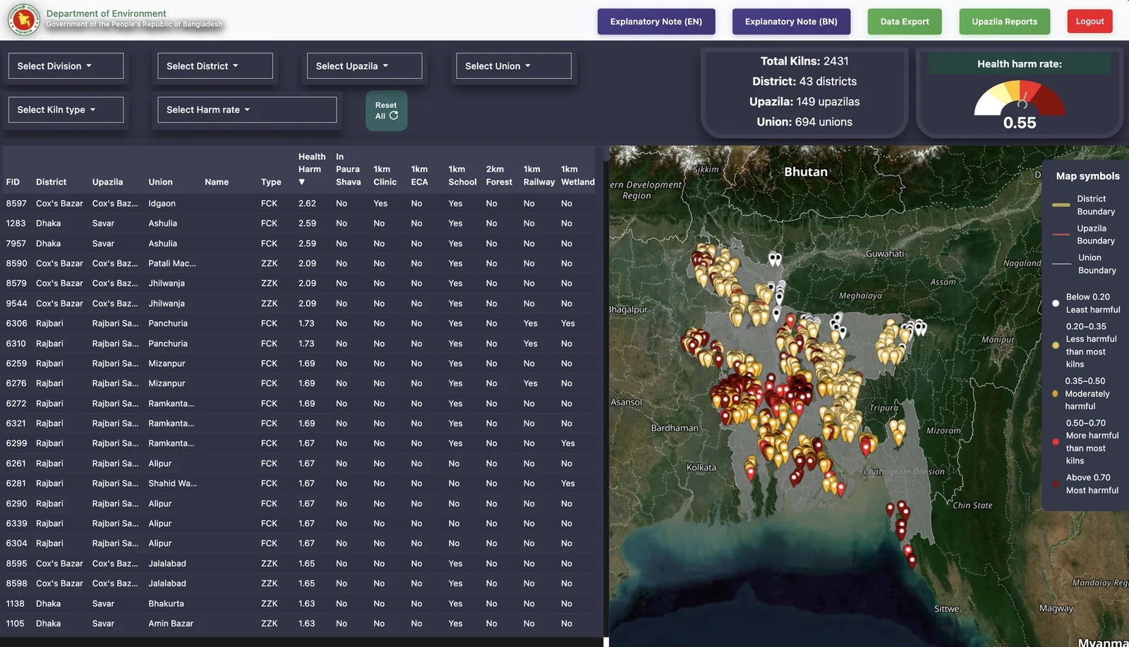
The tracker combines satellite imagery that locates each kiln with a pollution model that estimates its health harm from where the smoke travels and how many people live there. The tracker started from an earlier satellite survey that mapped each kiln’s location and design, but that survey did not show which kilns were firing. ARCED’s research assistants checked every kiln by hand in Google Earth Pro three different times. They confirmed each kiln’s coordinates, whether it was operating, and its design: an older fixed-chimney kiln, or a zigzag kiln, which sends the fire along a zigzag path through the stacked bricks so the fuel burns more completely (the DoE has directed kiln owners to switch from fixed-chimney kilns to cleaner designs such as zigzag). Because each round of checks took so long, ARCED trained a machine-learning model on the hand-checked records. Looking for a raised structure, a reddish tone and bare ground where nothing is growing, the model now identifies each kiln’s location and activity at once, with no manual checks. It can read satellite images too coarse for a person to interpret, and it updates every kiln’s status once a year.
The estimates were produced by a high-resolution, reduced-complexity air quality model, developed by Sumil Thakrar who was also part of the research team, and population data, which the ARCED team turns into a user-friendly dashboard for DoE district officers. Each kiln in the officer’s area appears as a pin colored by one of five bands of estimated health harm, from least to most harmful, and a click on it gives directions to the site.
Why we funded it
The tracker was past the prototype stage and ready to be tested in a real-world setting with the officials who decide which kilns to act on. It is rare for a Stage 1 grantee to begin with a randomized trial and a government already using the tool, as ARCED did.
We weigh every application on evidence of impact, durable scale and cost-effectiveness. A tool that changes how a government uses the staff and budget it already has is the kind of public-service innovation we fund, because it could prevent illness and deaths without new spending.
If the trial shows it moves enforcement toward the most harmful kilns, the DoE will have its own evidence for keeping the tool and extending it beyond the trial districts.
By the end of a Stage 1 grant, we want to know how an innovation functions in practice, whether people will use it, and whether it shows enough early promise to warrant deeper investment. With ARCED, we wanted to learn whether pollution estimates built from cost-effective satellite imagery and machine learning, once made usable, would change how the DoE enforces kiln rules. Information on which kilns do the most harm, and enforcement aimed at those kilns, are the early links in a chain that runs to fewer harmful kilns firing, cleaner air and fewer deaths. The same satellite and modeling methods can locate brick kilns and other fixed polluters elsewhere in South Asia, home to more than 2 billion people, so the answer matters to environmental enforcement officials well beyond Bangladesh.
The first question was whether district officials would use the tracker in their routine work. The second was whether, if they did, enforcement would move toward the kilns estimated to do the most harm.
What we’ve learned so far
Over the first 15 months, officials in districts with the tracker spent an average of 142 minutes a month on it and logged in more than once every two months, according to the team’s preliminary results that have been made public but have not yet been peer reviewed.
On the second question, the early results drawn from the DoE’s own enforcement records indicate that officials with the tracker took more enforcement action against kilns in the subdistricts estimated to do the most harm. For each standard deviation of higher estimated harm, subdistricts with the tracker added 52% more enforcement actions a month, relative to an average subdistrict without the tracker.

Enforcement was also more targeted. Officials with the tracker aimed fewer of their actions at the least harmful kilns. That share fell from 20% to 12% in treated subdistricts compared to their untreated counterparts.
Satellite images, which show whether each kiln is still firing, offer a second check. In subdistricts with the tracker, kilns with higher estimated harm were less likely to still be operating than in subdistricts without it, where about two in three kilns operate in a season. The gap grew by about 2 percentage points for each standard deviation of higher estimated harm.
Using the tracker’s data, in August 2025, the DoE declared Savar, a subdistrict near Dhaka, to be a degraded airshed. The designation restricts industrial polluting activities there. ARCED reports that the tracker’s averages of health harm for each subdistrict, calculated for the whole country, informed that decision. “We expected it to be used at the district level, within a particular subdistrict,” says Mattsson. “Instead it’s been used more strategically at the national level, to figure out which areas to focus on.”

Unexpected findings
DoE officials have worked the tracker into their routine in their own ways. Some print their district’s kiln list and work from paper, so the login data undercounts how much they use it.
"It was a double-edged sword," says Sheikh Rafi Ahmed, originally an RA on the project, and now a PhD student at NUS. "We got them to use the tracker, but once the lists were printed, they weren't going back into it."
Because some DoE officials preferred working from printed lists, ARCED added a data export option to the tracker. Officials can filter by region (district, subdistrict or union) and export a .xlsx, .csv or .pdf file with information on the selected kilns.
Keeping officials on board takes work too. DoE staff move between postings, and after a round of reassignments, ARCED retrained officials from October 2024 to February 2025. With each new appointee, the team has had to make the case for the tracker again. If the DoE keeps the tracker after the trial ends, it will have to train each new district officer.
What we don't know yet
We don’t yet know whether sending enforcement toward the most harmful kilns means the people downwind breathe cleaner air and fall sick less often.
Kilns are one of several sources of PM2.5 in Bangladesh, which makes changes in illness hard to trace to them. The trial estimates the change in health harm using the team’s model and satellite data on which kilns kept firing. The researchers estimate that closing the most harmful fifth of kilns nationwide would eliminate more than 40% of the health harm from brick kilns.
ARCED is building a version of the tracker that covers all of Bangladesh, a country of more than 170 million people. While the public tracker will only cover brick kilns, the same principle can be extended to other fixed sources of pollution that satellites can detect, including quarries and small industrial sites, and Mattsson sees it working for coal power plants and steel mills. If the tracker keeps moving enforcement toward the kilns whose smoke reaches the most people, as early results indicate, the fines and closure orders the DoE issues would take more PM2.5 out of the air those people breathe. Less PM2.5 means longer lives, by about a year for every sustained drop of 10 micrograms per cubic meter, according to the Air Quality Life Index.
What comes next
The kilns start firing again in November. DoE officials will have the tracker open (or printed out) when they do. Attention to air pollution peaks later, in winter, once the season is under way. "What we do this winter will help us next winter," Mattsson says.
The trial runs through December 2026, and the team expects to hold a public dissemination event later this year to present the findings from the study.
With the DoE receiving the expanded tracker, ARCED plans to update the data annually as new satellite imagery becomes available, and continue to provide operational support as officials use it to inform their enforcement actions.
Islam Al Faid, a research assistant at ARCED, grew up in Bangladesh, where, he says, people still have to feed themselves and secure shelter, so “thinking about the air quality is like a luxury to all of us.” Thinking about it is now his job. He and the team at ARCED built the tracker to sharpen the decisions officials make about which kilns to act on, so that clean air stops being a luxury.